> Due to the good public transportation in the Netherlands distance has become irrelevant. We can reach almost any destination by train easily and relatively quick.
Well that would be nice, but unfortunately not true. Our public transport is tolerable, but Covid accelerated drastic cuts in the bus lines out in the country that (used to) go where trains don't. This has lead to the creation of 'on call' buses which you can reserve in advance if you want to go to one of the villages affected, but which mean that the projected itinerary can only be achieved in ideal conditions. Normally, if one link in your public transport journey is delayed, you just take the next train or bus, but with these on-call buses you are now missing the last leg of the journey, and have to wait at least on hour for the next opportunity (minimum time between reservation and minibus appearing). These maps don't account for this, because it is focused on train travel and the time-distance to stations.
This time-maps are fun, but typical Amsterdam-centric thinking. And don't even bother trying to visit any bucolic place without train stations on a Sunday.
On the whole, public transport in the Netherlands, trains included, are not in a very good position¹. Partly due to the after effects of corona, partly due to a car-focused government.
1: Relative to neighbouring countries and pre-Covid conditions of course. This is still paradise compared to some countries.
I disagree. Lots of small towns have excellent train and bus connections. The idea that proper public transport only exists in and around Amsterdam is preposterous and, well, simply not true.
I agree that service to real small towns has gotten worse, and I agree that that’s stupid. But a large share of NL’s 400 train stations are in small towns too. Bus service to Tynaarlo going to shit does not mean that “public transportation time distance” is a useless, or “Amsterdam-centric” measure.
Service in small towns and villages has become worse (thanks to decades of free-market-politics). I live in such a village.
But that, indeed, does not mean that public transport is bad. It's still very good. Just less good for a minority.
My situation is that I always need (2x) extra 25 minutes on bike before I can hop on a train. A car hardly increases that speed. A taxi might be faster (due not having to park), but they are (always have been market-driven) unpredictable: they don't like driving to/from a small village.
I often need "last-leg" journeys in remote areas too. Dutch public transport has excellent bike-services. I'll just grab a bike (OV-fiets) at the train-station and cycle to where I have to be. Sure, over 30-minutes makes the entire journey longer than car. But 25 mins bike + train@150km/h + 30 mins bike is most often still faster than a car. And I can drink a beer, code some stuff or watch a netflix on the train. And have 1:50m of light workout under the belt.
Point being: maybe it's getting less-good. And it's good that people complain about that (if only they voted like this too). But most often this complaint is really little more than repeated hearsay; a pretext to keep driving in a car.
Having seen the quality degrade in the 12 years I've been living here, I tend to agree that it's not as good as it used to be. Heck, 5 times just this month I had to go back home and pick my bike because the bus had been canceled and I couldn't reach a main hub any more.
That being said, I've been living in other countries and the quality of service is INSANE compared to many other countries. We quickly forget how easy we have it.
People take the train in NL like they take the bus in major cities in France. I hope it'll stay as good in the future, and the shortage stops at some point.
People take the train in NL like they take the bus in major cities in France
Could you please elaborate? (I am not sure I understood your comment)
In France we do take trains on a regular basis, especially in major cities (the NL population is 17M, the paris region is 12M and largely crossed with trains)
I am pretty certain the parent's analogy was that (the non-Paris) French cities typically can fund bus service routes just as widely convenient as (the non-Amsterdam) Dutch cities typically can fund train services.
It was not at all a putdown of France, which, after all, does fund many more long distance TGV routes out of geographic necessity; just a favorable comparison of how conveniently widespread the medium-speed train routes are in the average Dutch metropolitan region.
Sorry, I was not clear in my comment. I did not assume at all that this is a putdown of France (it's our national holiday tomorrow :)) - I was just unclear about the comparison of buses and trains (as they indeed require vastly different infrastructures and costs).
My bad, my comment was maybe written too much from my perspective, and with the Dutchies here in mind.
I meant that in terms of convenience. Pretty much half the country uses trains to get to and from work everyday in the Netherlands, with trains running every 15 minutes from pretty much all directions. Maybe 30 minutes for smaller connections. I get trains running every 15 minutes from Utrecht from 7AM to 1AM.
So my point was "as a user taking the train is such a convenience that I take it without even having to sync with the scheduling. I just go to the station, the same way I used to do in France with buses". Except it's for the whole country.
Of course, the country is smaller, flat, . . . there's millions of differences.
I was mostly responding to "Our public transport is tolerable", trying to bring external perspective to the comment.
No, it is me who just could not understand the relationship, taken into account the vastly different technical means and population size. Now I got it (also thanks to the daughter comment).
That reminds me of my youth, where my cousin (a city kid) would complain about needing to wait 10 minutes for a bus, while I had to wait for a bus that was going every two hours — in the Alps. Alpine winters being not something during which you wanna wait two hours at an unsheltered bus stop. I sometimes decided to go on foot with the hope to be at the next stop before the bus (or stop the bus inbetween if the driver was nice enough).
Another friend had one bus a day.
Nowadays I live in the city and would complain if I had to wait for 5 minutes. How we reason about public transport quality is very relative to our expectations.
The tiny town (not village) of Stavoren is fortunate enough to actually have a train station (not to mention a ferry link to Enkhuizen). That it still has a train link is a miracle in itself. A lot of those lines were on a razor's edge in the nineties, and if they had gotten replaced by buses (as was considered even for the larger towns of Harlingen and Franeker) they would have been harmed quite a lot by now (significant loss of tourism and being less attractive to live in).
Try Lollum, Burdaard, or Earnewâld by bus! Similar in population to Stavoren, no train, no dedicated bus line (anymore).
I just spent a week in Aalsmeer, which is a 40 minute bike ride from Amsterdam (or a 40 minute drive). Since it doesn’t have a train station it was inconvenient to get anywhere without a car. That said, if you are near a train station, pretty much all the major cities are within 30ish minutes of one another.
That said, I think it’s more a function of the Netherlands being a small, flat and dense country than having great public transit. You could probably bike between most major cities in less than 90 minutes.
Interesting view of the Netherlands, but you can't reach most of the ten largest cities in the Netherlands within 30 minutes by train or 90 by bicycle from most of the other cities. Eindhoven, Groningen, Tilburg, Breda, Nijmegen are all quite a distance from Amsterdam, and even the rail journey from Almere to Rotterdam takes over an hour.
That one was interesting, but seems to be missing some data about regional trains in Sweden. Even though commuter trains around Stockholm seem reasonably correct.
Isochrone should follow the transport graph and is not just a nested circles (aka buffer) going out of centroid of shape… this article is somewhat misleading and also a bit sensational since people been doing isochrone analysis and maps for decades
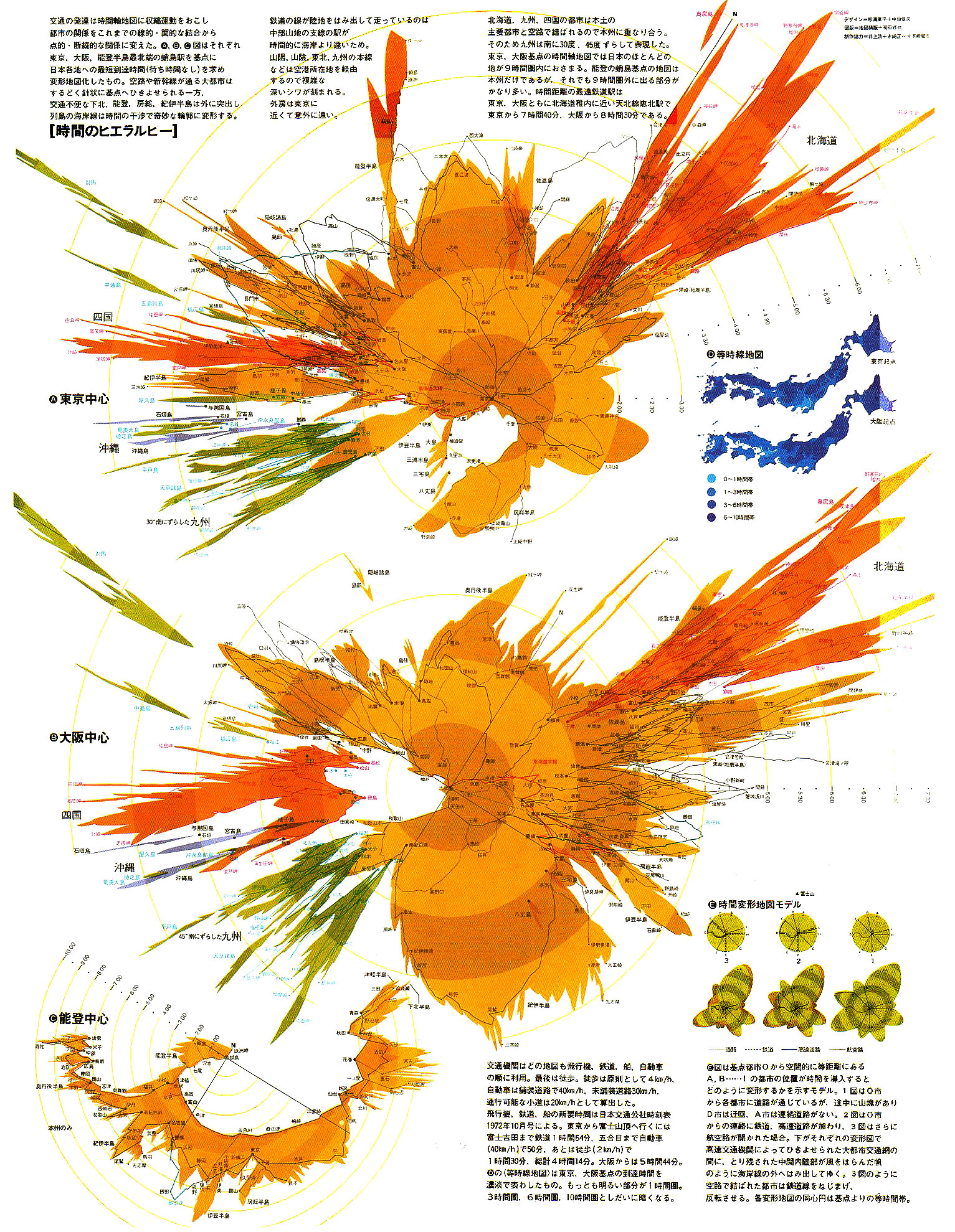
In Japan, there exists a similar map created in 1970s by Yasuhira Sugiura (designer). It's not in English, but the image below depicts Japan from Hokkaido to Okinawa. The upper part is centered on Tokyo. The lower part is centered on Osaka.
Good idea. But not easily usable. The map distortion is funny and impressive but not practical. The (arbitrary) colored circles should be distorted to bring information, not the (familiar) map itself. We need the map to stay familiar so people are able to easily use this.
I remember seeing an isochrone map of the time it would take to reach different parts of the world in 1900, with London as a start point. I can't remember the actual times but it took weeks to get to Australia, and then additional weeks to get into the interior (few road and railways at then).
It emphasized that travel to a foreign country, let alone emigrating, was massively more complex than today.
I like the idea, but find the color bands a bit distracting since they're obviuusly incorrect - actual travel times are going to be shorter to navigation hubs and longer the further out in the network you get. It'd be more complicated to implement, of course!
This is why for this kind of map the geography is usually left as-is in one of the usual common projections, with a colour scale marking the time-distance, rather than distorting the geography.
Agreed. These might be nice to have on the wall, but there are a lot of projects that have produced accurate maps over the years. A Google for "travel time map" brings up loads, such as https://app.traveltime.com/ which lets you make your own.
Me and friends are in [Location] and are willing to travel no longer then [Time] to [some activity] - show all recommended places for [some activity] within radius [Time]
> Due to the good public transportation in the Netherlands distance has become irrelevant.
Is there some kind of global index that measures how good public transportation is in major cities of the world? It'd be interesting to which cities rank at the top.
Can I request the well-traveled to share on this thread which cities they found to have the most excellent public transportation?
What is "good public transport"? A tiny village with 24 souls and one busline will probably have more "public transport opportunities per capita" than Tokyo.
A very dense city has lower travel times than a spread out (or mountainous) city even if their "amount of PT" is exactly the same.
As such, "good public transportation" either needs an entire bookwork to describe the metrics (and is therefore rather unusable), or is just a highly subjective metric.
One thing I noticed when moving from San Diego to Albuquerque as a teen was how normal it was in Southern California to answer the question "How far is X?" with the answer "30 minutes". That was due to freeways and traffic rather than public transit but I definitely get the idea of these kinds of maps.
How would folks recommend implementing visualizations like this? I'm willing to program at a layer or two beneath "make an isochrone graph". My interests are more for visualizing embedding spaces such as those produced by RAVE or other VAEs.
Well that would be nice, but unfortunately not true. Our public transport is tolerable, but Covid accelerated drastic cuts in the bus lines out in the country that (used to) go where trains don't. This has lead to the creation of 'on call' buses which you can reserve in advance if you want to go to one of the villages affected, but which mean that the projected itinerary can only be achieved in ideal conditions. Normally, if one link in your public transport journey is delayed, you just take the next train or bus, but with these on-call buses you are now missing the last leg of the journey, and have to wait at least on hour for the next opportunity (minimum time between reservation and minibus appearing). These maps don't account for this, because it is focused on train travel and the time-distance to stations.
This time-maps are fun, but typical Amsterdam-centric thinking. And don't even bother trying to visit any bucolic place without train stations on a Sunday.
On the whole, public transport in the Netherlands, trains included, are not in a very good position¹. Partly due to the after effects of corona, partly due to a car-focused government.
1: Relative to neighbouring countries and pre-Covid conditions of course. This is still paradise compared to some countries.